Arguably, this should go on my history blog. But it is train reading, and Wednesday is my sometimes irregular day for Australiana.
I mentioned the Mooki River in my post Sunday Essay – maps, myopia and the Aboriginal story. Now I am reading H R Carter’s The Upper Mooki (published by the author in association with the Quirindi and District Historical Society, second edition, Quirindi 1975).
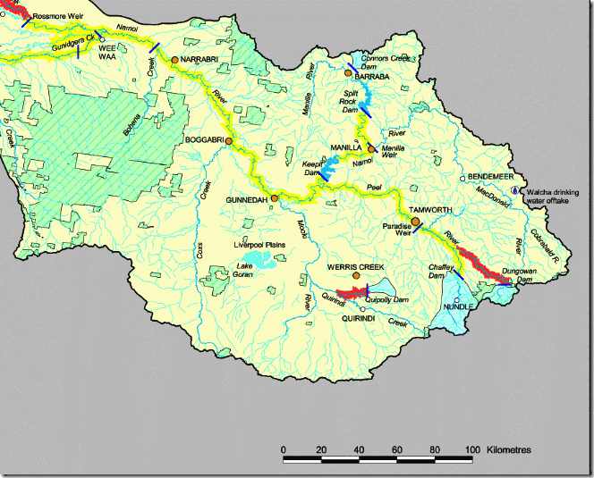
The following map, I apologise for the resolution, is to help you orient yourself. The map is an excerpt from the Namoi River catchment map. It’s actually quite an interesting map beyond my interest in Mr Carter’s book. Let me explain.
This little slice of country lies at the heart of a fair bit of Australian politics in recent years. The Naomi River flows through the Liverpool Plains. This is Tony Windsor Country. Just of to the right of the map at Woolbrook Barnaby Joyce, Tony’s replacement as member for New England, grew up before going to school in Tamworth and then to to the University of New England.
Now focus on that yellow line that runs though Gunnedah, Boggabri and Narrabri. That’s the Namoi. The Gunnedah, Boggabri, Narrabri strip is part of coal central. This is where some of the fiercest environmental battles are being fought out, including the case of Jonathon Moylan and Whitehaven Coal. That green hatched strip on the left is the Pilliga Scrub. That’s where environmentalists and Santos are fighting it out over coal seam gas. Further comments follow the map.
 If you look at the bottom centre of the map, you will see the Mooki River. The river rises in the Liverpool Ranges at the southern edge of the map, part of the great dividing range that forms the northern edge of the Hunter Valley. Unlike the barrier imposed by the Blue Mountains east of Sydney, the range here is relatively low. Once stock reached the Hunter Valley, they could move north. By 1827, an estimated 10,000 cattle had already reached the Liverpool Plains.
Because one of the the easiest paths led into the into the Mooki River valley, this area was quickly occupied by European settlers, It was also an area of some conflict with Aboriginal people. The story here is complicated. I will deal with it in a separate post.
The strength of Mr Carter’s book lies in its detail. He traces the history of every property from the first European settlement to the start of the 1970s. He provides short biographical details on each landowner and many of the people who worked for them. He also adds some specific details on things such as changing farming practices. The book is, in fact, the results of almost a lifetime of research into that particular small area Mr Carter called home. Mr Carter himself was a long standing president of the Quirindi and District Historical Society.
The book’s strength is also its weakness. The detail involved would probably be very boring for a reader who does not know the area, although even then there would be parts of interest. To someone like me who has some knowledge of the area and who is already familiar with many of the names, it is very interesting indeed.
There is also a connection with our own small blogging village. Neil Whitfield’s grandfather taught at Braefield, a small school near the Mooki Valley. Neil described this experience in a family history post back in 2008, More tales from my mother 3 — Braefield NSW 1916-1923. Note the picture of the phaeton in that post. I will come back to that in another post.


No comments:
Post a Comment